

UPDATE:
Weather models are showing increased uncertainty for this week's winter storm forecast across Central Texas, with warmer temperatures now expected to delay freezing conditions until Saturday morning.
The latest model runs indicate a significant shift from earlier predictions, with temperatures now forecast to struggle falling below freezing until Saturday. This change means the first round of heavy precipitation may fall as rain rather than ice, which meteorologists say is beneficial for the region.
The warmer shift has created about a 100-mile difference between the two main forecast scenarios. However, meteorologists expect the final outcome will likely fall somewhere between the two models, potentially favoring slightly colder conditions.
Saturday will mark the beginning of icy impacts as cold air continues moving south, eventually sending the entire area below freezing. The delayed freezing timeline is also expected to reduce overall ice accumulations compared to earlier forecasts.
Signs point to dry air potentially splitting the precipitation into two separate rounds late Saturday. The second round could feature more sleet and possibly a brief switch to snow on Sunday.
Meteorologists plan to provide more specific timing details and discuss possible accumulation totals within the next day as the forecast becomes more certain. Despite the warmer shift, winter weather impacts are still expected across the region.
KXXV will continue monitoring the developing weather situation and provide updates as conditions change.
This story was reported on-air by a journalist and has been converted to this platform with the assistance of AI. Our editorial team verifies all reporting on all platforms for fairness and accuracy.
THE BREAKDOWN:
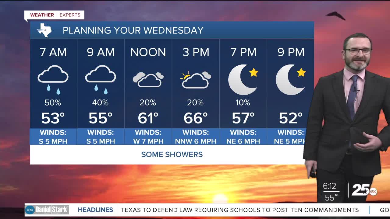
- Some showers will be possible, mainly east of I-35 today.
- Nice and quiet Thursday.
- Arctic front arrives midday Friday.
- Winter storm impacts still expected this weekend.
Good morning! We're waking up to some showers to start off your Wednesday as moisture has increased across the area. The best chances this morning will be east of I-35, but this will all be liquid rain with temperatures well above freezing. Activity should taper from west to east across the area through the day, with even some sunshine possible west of I-35. If we can get into the sunshine, we could see some highs closer to the low 70s west of I-35. Overnight into Thursday looks quiet with lows in the 40s and highs getting into the mid 60s.
Friday continues to look to be the day of changes here in Central Texas as our strong arctic cold front is set to arrive during the day. There has been a slight shift northward/slower in the models, but I think we are still on target to see freezing temperatures work in as early as midnight Friday. That's when rain would switch to freezing rain and sleet. The key will be where our temperatures are. Will we be in the upper 20s, or the lower 30s? If we get to the upper 20s with widespread freezing rain, that would lead to more icing on roadways. We won't know the answer to that until a day out. Freezing rain and sleet is expected to continue through the day Saturday as temperatures fall into the 20s. We may see another round of precipitation into Sunday, which would be more of a wintry mix. Eventually all activity exits by Monday allowing for frigid overnight temperatures into the teens! Be sure to winterize your home in the next couple of days as we will likely spend 72 hours or more below freezing.
We will keep you posted, have a great Wednesday!
Meteorologist Josh Johns
25 Weather
Want this forecast delivered to your inbox each morning? Sign up for the daily forecast email newsletter here.
