


CENTRAL TEXAS — Intense flooding hit Waco this evening as a boundary of storms exploded over McLennan County. Multiple roads were flooded, including I-35 south of Waco, near Hewitt and Robinson. These storms finally started marching southward thanks to an advancing cold front. The storms are producing so much rain that flooded roads tonight will continue to be a danger. Several Flash Flood Warnings have been issued to caution drivers overnight.
Flash Flood Warning issued for Milam County until 2:30am.
Flash Flood Warning issued for Falls County until 12:30am.
Flash Flood Warning issued for McLennan County until 12:30am. This is the storm that first hit Waco after 8am and has since dropped over 5" of rain, with the hardest hit areas being around Hewitt.
Flash Flood Warning issued for sections of Bell, Coryell, Falls McLennan Counties until 12:30am.
Flash Flood Warning issued for Bell, Coryell, and Milam until 12:30am. This is the warning that includes Temple.
And two seperate Flash Flood Warning issued for Burnet County until 1am and 2:45am.
Flood Watch issued for all of Central tonight for tonight and through Monday evening. Slow moving thunderstorms will be capable of producing 3 to 5 inches of rain in a short period of time, especially if they are near stationary.
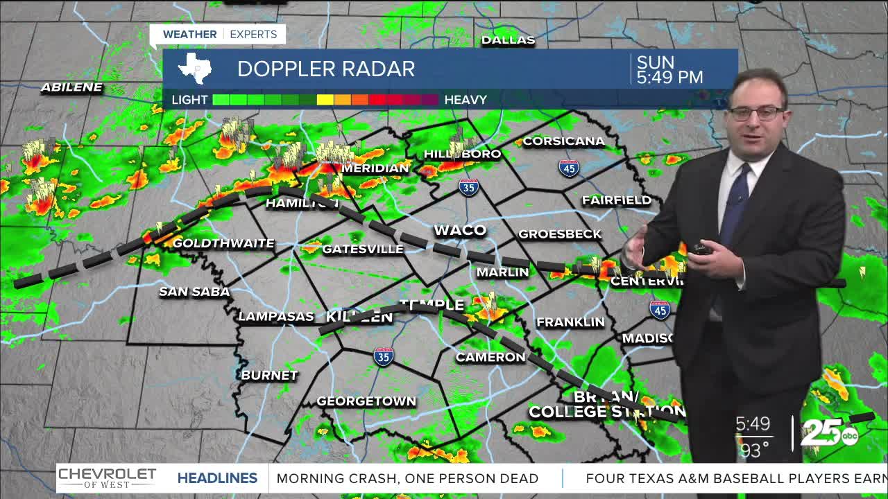
5pm Sunday Update: The cold front responsible for the action today is currently over Dallas and slowing moving southward towards Central Texas. An outflow boundary has stalled directly over a Hamilton to Waco to Grosbeck line where scattered showers continue to bubble up. Thirdly, another boundary associate with the Gulf sea breeze is moving northwards past the Brazos Valley. If these boundaries intersect, we could be on for some stronger thunderstorms and very heavy rainfall under those storms which may not be moving very fast. Not a "severe weather" risk, but a flooding risk for locations caught underneath the storms. Like we've seen recently, 3" of rain or more can cause flooding for flood prone areas and nearby river banks.
The cold front will be passing through Central Texas tonight or early Monday morning. More storms will still bubble up along the outflow boundaries, meaning another solid chance for storms across the area Monday. Greatest chance for rain will be southeast / Brazos Valley, lower chances to the northwest of Waco. Temps will be a lot cooler! Highs in the low 80s for a day or two.
Next week, we'll be monitoring a tropical disturbance which is currently over Mexico and slides into the Gulf just off the coast of Texas. Whether or not this becomes a named Tropical Storm or not, heavy rain is likely along the coast from Corpus Christi to Galveston. Storms could reach the Brazos Valley and Central Texas Friday... but I believe the rainfall will have a sharp cutoff between rain and dry locations. So more of an all-or-nothing forecast where we're at a 60-70% chance to stay on the dry-side of this tropical disturbance. More details to come.
- 25 News Meteorologist Thomas Patrick
Want this forecast delivered to your inbox each morning? Sign up for the daily forecast email newsletter here.
