

Midday Update:
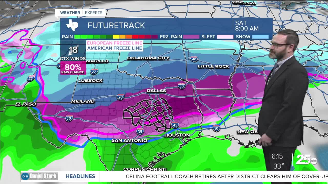
A significant winter storm is expected to impact Central Texas this weekend, with freezing rain and sleet likely as temperatures drop below freezing.
Weather models have shown increasing consistency over the past 24 hours, giving meteorologists greater confidence in the storm's arrival and potential impacts.
The storm front is now expected to arrive as early as Friday morning, with temperatures potentially falling below freezing by Friday evening. This would turn any rain into freezing rain as the system moves through the area.
The most critical period appears to be Saturday morning, when temperatures could drop to 28-29 degrees. At these temperatures, ice accumulation on roads becomes particularly dangerous, creating widespread travel impacts regardless of the total ice amount.
The storm presents a challenging forecast scenario due to atmospheric conditions. While surface temperatures will be cold enough to support wintry precipitation, warmer air in the mid-levels of the atmosphere means the region will likely see freezing rain and sleet rather than snow.
Two key factors remain uncertain and could significantly impact the storm's severity:
- The temperature profile in the mid-levels of the atmosphere will determine whether the area sees more freezing rain or sleet. Both create hazardous conditions, but freezing rain typically causes more widespread problems.
- The storm system's track could also affect the duration and intensity of the event. Some models suggest the low-pressure system could move directly over Central Texas and continue south, potentially bringing another round of precipitation Sunday into Monday that could fall as snow. This scenario would extend the winter weather event and bring even colder temperatures into early next week.
Most of Saturday is expected to feature travel impacts as the storm system moves through the region.
Residents are advised to begin preparations now while continuing to monitor official weather updates as the forecast develops.
This story was reported on-air by a journalist and has been converted to this platform with the assistance of AI. Our editorial team verifies all reporting on all platforms for fairness and accuracy
Tuesday will be quiet with highs getting into the upper 50s and low 60s. Some rain chances pick back up Wednesday with a winter storm likely this weekend.
THE BREAKDOWN:
- Cloudy day with highs in the upper 50s and 60s for Tuesday.
- Scattered showers possible Wednesday.
- Arctic front arrives Friday.
- Winter storm likely this weekend with icy impacts expected.
Good morning! We're waking up to a chilly morning with more cloud cover around. That will struggle to clear at times today, keeping highs in the upper 50s and low 60s. The cloud cover is a sign of the increasing moisture that will eventually turn into some scattered showers on Wednesday. Highs Wednesday will make it into the 60s, with some clearing possible by the end of the day. Expect things to remain cloudy Thursday with highs in the low 60s as we prepare for our next incoming storm system.
Friday is the day of change here in Central Texas as a strong cold front moves into the Lone Star State. The front should arrive during the middle of the day Friday, but may arrive as early as the morning. Models have sped up the cold air, suggesting that we could see temperatures fall below freezing as early as Friday night. That means that during the day Saturday we will likely see widespread freezing rain mixing with sleet at times. This will lead to icing and travel impacts. It is too early to nail down exact timing and totals, but I'd advise against travel Saturday. There will be a small chance for this to switch over to snow overnight Saturday into Sunday, but the majority of this will fall as ice. Sunday may feature drier conditions, but it will still be below freezing, so travel is not advised. Temperatures may fall into the teens Monday morning, and may finally climb above freezing during the day Monday. Prepare now for these impacts, and the potential for temperatures to remain below freezing for more than 48 hours.
Stay tuned, we will keep you advised on the coming storm.
Have a great Tuesday!
Meteorologist Josh Johns
25 Weather
Want this forecast delivered to your inbox each morning? Sign up for the daily forecast email newsletter here.
