

CENTRAL TEXAS — Our arctic cold front will move in later on this afternoon, with temperatures falling below freezing in spots overnight. Freezing rain may start as early as Saturday morning.
We have broken it down into a timeline for you to easily follow impacts in your neighborhoods.
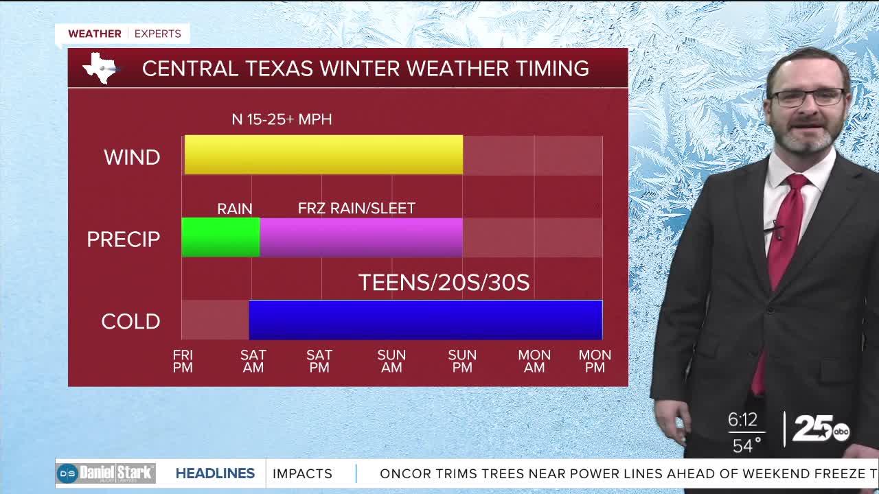
WINTER STORM TIMELINE:
- Friday :
- Arctic front arrives in the afternoon with falling temperatures.
- All rain, with scattered showers expected.
- Friday night:
- Wind chills near the freezing mark, but rain stays liquid as temperatures fall into the 30s.
- Mainly rain.
- Overnight Friday - Saturday morning.
- Temperatures fall below freezing north of Waco, with freezing rain starting to accumulate along elevated surfaces.
- Feel-like temperatures fall into the 20s.
- Saturday morning - Saturday midday.
- Freezing line works into Waco-Temple-Killeen
- Transition from rain to freezing rain along the I-35 corridor.
- Saturday afternoon
- Freezing line could near highway 79.
- Freezing rain across Central Texas.
- Wind chills in the teens.
- Saturday night.
- Widespread freezing rain and sleet as freezing line works through the entire area.
- Heaviest precipitation.
- Sleet mixes in across Central Texas
- Wind chills in the teens
- Sunday
- Sleet ends from west to east.
- Light snow possible.
- Bitter cold sets in.
- Temperatures in the 20s
- Wind chills may dip into the single digits.
- Monday Morning
- Morning lows in the single digits
- Wind chills could dip below 0.
- Dangerous cold.
- Monday
- Temperatures stay below freezing, but ice begins to melt slightly from sunshine.
- Roads still an issue.
- Wind chills in the teens
- Overnight - Tuesday morning.
- Temperatures once again fall into the teens.
- Wind chills in the single digits.
- Tuesday afternoon
- Temperatures warm back above freezing as we reach the 40s.
- Wind chills in the 20s.
TOTAL ICE ACCUMULATIONS
- Central Texas
- Freezing rain accumulations 1/4-1/2 inch, with isolated 3/4 inch totals.
- Sleet accumulations 1-3 inches.
- Brazos Valley
- Freezing rain accumulations 1/10-1/3 inch, with isolated 1/2 inch totals
- Sleet accumulations up to 1 inch.
Once the winter storm wraps up, we will see a slow thaw out into the 40s for highs during the middle of next week. There is another system coming by next Friday that could bring more wintry precipitation but its still early! Next weekend looks cold as well.
Stay safe and have a great weekend!
Meteorologist Josh Johns
25 Weather
Want this forecast delivered to your inbox each morning? Sign up for the daily forecast email newsletter here.
