
CENTRAL TEXAS (KXXV) — Central Texas experienced a significant temperature rebound today, with highs reaching near 70 degrees across the region after yesterday's cooler conditions that only reached the 50s.
The Waco airport recorded temperatures close to 70 degrees, with the official reading hitting exactly 70. Other area locations saw similar warmth, with Gatesville reaching 68 degrees, while Temple and Cameron both hit 70 degrees. Bryan College Station recorded 69 degrees, putting temperatures slightly above average for early February.
High clouds streamed across the region throughout the day and will continue to thicken overnight. South winds will remain breezy at 10 to 15 mph, with mostly cloudy skies expected through the night.
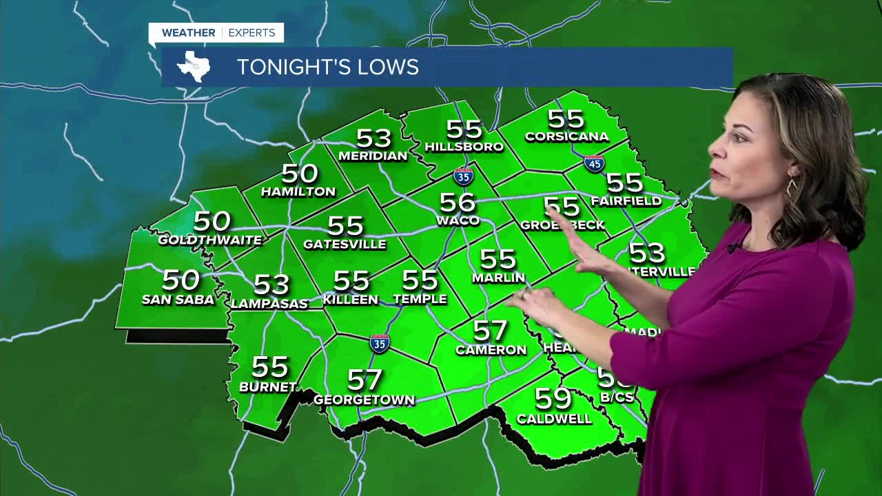
Tomorrow morning will bring a dramatic change from today's start, with wake-up temperatures in the 50s compared to the lower 30s experienced this morning. Northwestern communities will see lows around 50 degrees, while areas along the I-35 corridor will bottom out in the middle 50s. The Brazos Valley will stay warmer, with temperatures closer to 60 degrees.
Cold front brings scattered shower chances
A cold front approaching from the north and west during tomorrow afternoon could spark widely scattered showers. Any rainfall will be light and scattered, meaning many areas may not see precipitation at all. Some locations could experience brief showers, with the front moving southeast toward the Brazos Valley and potentially producing isolated thunderstorms. No severe weather is expected.
Despite the approaching front, tomorrow will remain mild since the system arrives later in the day. Waco will reach 66 degrees, while Temple and Killeen are forecast for 68 degrees. Lampasas will see 66 degrees, Marlin 68 degrees, and areas from Hearne down to Caldwell and Bryan College Station could reach 70 degrees.
Brief cooldown before weekend warmth
Wednesday will bring the week's coolest temperatures, with highs in the upper 50s to lower 60s. The cooldown will be short-lived, with middle 60s returning Thursday and temperatures climbing back into the 70s by Friday.
The upcoming weekend looks significantly warmer and more pleasant compared to recent conditions, with 70-degree temperatures continuing through Saturday and Sunday. Morning low temperatures will also moderate, reducing the chill factor for early risers.
The weather pattern may become more active early next week, with potential rain chances returning Monday and Tuesday as high pressure moves out of the region.
Want this forecast delivered to your inbox each morning? Sign up for the daily forecast email newsletter here.
This story was reported on-air by a journalist and has been converted to this platform with the assistance of AI. Our editorial team verifies all reporting on all platforms for fairness and accuracy.
