
CENTRAL TEXAS (KXXV) — Keep up with our 25 News Weather Experts for the latest on weather conditions in your neighborhood as we see locally heavy rain and few severe storms possible Friday night and into Saturday morning.
Submit your weather photos and videos here.
Saturday, October 25
2:30 p.m.
SEVERE T-STORM WARNING issued through 3:30pm for HILL and BOSQUE co. Half dollar size hail and 60mph winds are possible as this storm moves E from Whitney to Hillsboro. Head indoors and away from windows!
2:11 p.m.
10:10 a.m.
8:25 a.m.
Radar shows some rain activity moving across the Brazos Valley, but mostly clear in Central Texas. You can track the rain using our interactive live radar.

8:15 a.m.
Power outages on the Bryan Texas Utilities outage map:
Brazos - 214
8:00 a.m.
Power outages from the Oncor outage map:
Bell - 1,341
Coryell - 666
Freestone - 121
Lampasas - 145
Leon - 21
Limestone - 28
McLennan - 56
Milam - 28
8:00 a.m.
Power outages on the Heart of Texas Electric Co-op outage map:
70 outages in service area
Friday, October 24
10:52 p.m.
The Robinson Volunteer Fire Department responds to a possible lightning strike in Robinson. Firefighters entered a home and attic and are investigating the scene, and all occupants evacuated the home safely.
9:47 p.m.
9:08 p.m.
Facebook Live with Chief Meteorologist Matt Hines:
8:36 p.m.
Viewer video in Bosque County, near the Katy Bridge, showing lightning in the distance.
8:30 p.m.
8:21 p.m.
A Severe Thunderstorm Watch is in effect for the northwestern half of the area until midnight, and southeastern half until 3 a.m.
Winds over 60 mph will be the main threat with the strongest storms.
8 p.m.
Facebook Live with Chief Meteorologist Matt Hines:
7:44 p.m.
Severe Thunderstorm Warning in effect until 9 p.m. for northern Bosque County, with winds up to 70 mph.
A Severe T-Storm WARNING is in effect until 9pm for northern Bosque County. Winds up to 70mph are possible. #ctxwx pic.twitter.com/OCf9SLG4i7
— Matt Hines 🌵 (@MattHinesTX) October 25, 2025
5:14 p.m.
Severe Thunderstorm Watch issued until midnight:
A flood watch has also been issued for parts of Central Texas Friday night through Saturday morning:

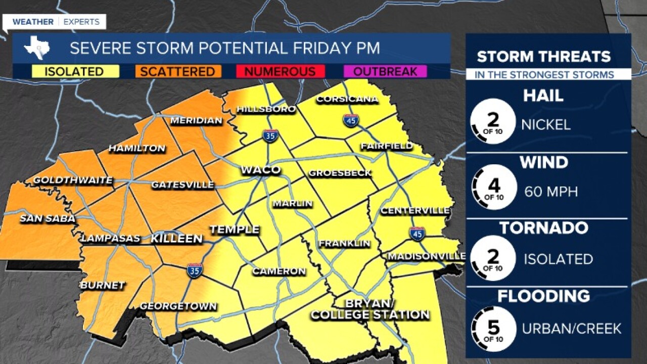
2:30 p.m.
9:29 a.m.
Some light rain showers passed through Waco Friday morning - just enough to puddle on the ground and dry up by the afternoon.
